Let’s ask ESA to improve Sentinel-2 multi-temporal registration
Update from May 4th 2018 : ESA has started planning for a global reprocessing in 2019
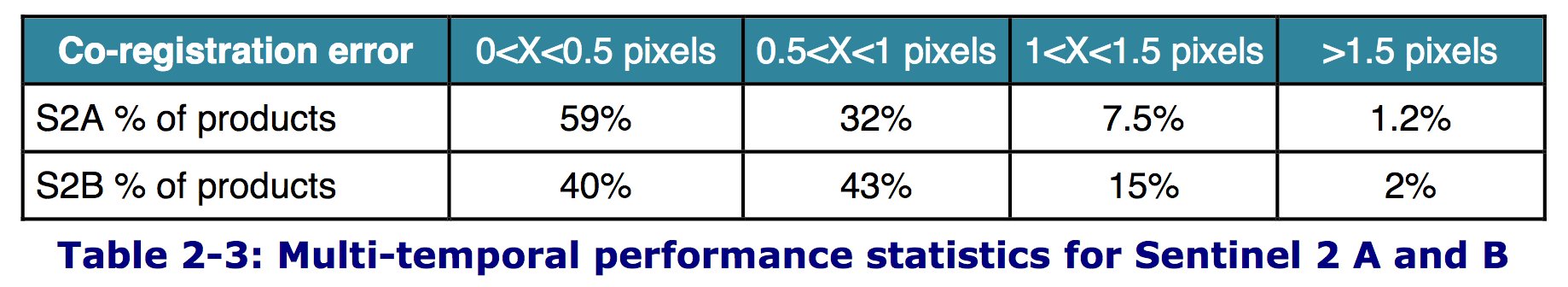
The information gathered by Sentinel-2 system on Sentinel-2 orbit, attitude, date accuracy, and viewing directions of all detectors allows an excellent accuracy for the geolocation of all Sentinel-2 pixels. The overall geo-location accuracy is better than 11 or 12 meter, for about 97 % of the cases, which is about the size of one Sentinel-2 pixel. Such a performance is more or less equivalent to that obtained for Pleiades, but Pleiades has a resolution of 0.7m. It is therefore really an achievement, which is to be credited to ESA, to the satellite and instrument manufacturer, and to the image quality teams (including my CNES colleagues). But even if it is excellent, it is not enough. The standard need for multi-temporal registration errors is 0.3 pixels, and the current performances show that for more than 50% of the cases, the performance does not meet that requirement.
For many users, I guess, these figures do not mean much, and it is not easy to figure out their impact on real life applications. The animation below (made by the twitter star Simon Gascoin) makes that much more concrete :

Time series of Sentinel-2 images of the construction of Nour solar power station near Ouarzazate in Morocco. (made by Simon Gascoin using Sentinelhub)
Now, you see the vibrations, I guess. As the scene can be observed from two different orbits, part of the tremor was due to a bias in the yaw calibration parameter, which was solved in May 2016. As time goes by, an improvement is therefore noticeable, even if the images still viber. Imagine now that you want to process a time series of data, for instance to produce a land cover map. These vibrations will result in a blurred result, and finally, the final resolution of your product will be much reduced. Using that rule of thumb of a resolution which is 3 times the registration error, we could say that the resolution of Sentinel-2 time series is 30m. Which is a pity, given the user needs as well as the additional costs to pass from a 30m resolution instrument to a 10m resolution instrument. There is of course a solution for that, which is using ground control points, obtained using automatic image matching techniques to a Global Reference Image. The methodology to make this GRI was defined by colleagues from the French Cartographic Institute (IGN). It is a large scale triangulation method using Sentinel-2 cloud free data, continent by continent. Elaborating the GRI took a long time, with a difficulty related to the collection of almost cloud free images. The Europe and Australia reference images were ready one year after launch. Still, the registration is not operational yet. My colleagues in CNES defined the methods, and even provided libraries to do that, but ESA decided to start the development from scratch with new industry providers. The software produced 3 years after launch still has performance issues. It is simply not able to process in real time all the data provided by Sentinel-2. As a result ESA just announced that using ground control points will only start next year. Well that’s easy to criticize (and I am known as an easy critic, this blog post will not help my reputation), but specialists know that Image matching techniques need very large computational resources, and therefore the task is really hard. Anyone who has already downloaded a Sentinel-2 image can imagine the data volume to process and reprocess and the computational resources it involves. Speaking of reprocessing, what I am very concerned of is also that when I asked if the older Sentinel-2 data would be reprocessed, I was answered by Sentinel-2 project manager.
» there are no plans to reprocess the older data »
Archive data are really important, many users work on change detection, long term trends, compare crop development of the current year to older data. One of the reasons not to reprocess is that a very high percentage of all downloads concerns the most recent data. That’s probably true, but if we tend to download the most recent data, isn’t it just because we already have the older ones ? So, I think we should urge ESA and Copernicus EU to consider a major reprocessing of Sentinel-2 data as soon as the operational version of ortho-rectification with ground control points is available.