The version 331 of the L3 brightness temperatures on the polar projections presented a slight shift in latitudes and longitudes, creating a geolocation error inducing a misalignment visible with the shore line. This effect can be seen for instance in the left figure below, where blue dots (low brightness temperatures corresponding to water) on land, when the values should be higher (yellow/orange/red). As the shift was not linear, we could not suggest a simple approach to correct the geolocation shift.
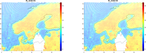
To sort the issue we produced a new version of the processor, which is now version 332 available on the CATDS. The right hand side of the figure corresponds to the new version, and it can be seen that the TB are now well aligned with the shore.
The correction is applied to both the Southern and Northern grids, and should allow accurate geolocation of SMOS measurements at high latitudes on the polar grid.
This new version is available from the December 2023. The archive is NOT reprocessed for the time being, and the period 2010 – 2023 is to be considered with cautio.
Reprocessing of the whole archive with the new processor will be carried out and we will keep you updated once we have reprocessed the complete archive of the level 3 TB polar.
Stay tuned.
Arnaud Mialon