SMOS was originally designed to measure ocean salinity and soil moisture / vegetation optical depth from space. Over time its range of applications expanded, to include for example thin sea ice thickness or strong winds over oceans. Nowadays, a new field of exploration concerns high latitudes areas with all their complexities (frozen soils/vegetation/water, snow covered areas, organic soils, etc..). In a changing climate environment it is necessary to improve our monitoring these areas. The question being: what pieces of information can be derived from L band multi-angular measurements to better monitor high latitudes?
Focussing on soil permittivity (a parameter sensitive to soil water content) and vegetation optical depth (a proxy for the presence of above-ground vegetation and its water content), the Finnish Meteorological Institute (FMI) team tentatively addresses snow density retrievals in the Sodankylä region (Northern Finland).
M. Holmberg informs us on advances on snow density retrieval in a recent paper, which presents the studies carried out at the Finnish Meteorological Institute’s Space and Earth Observation Center. In this article, previously published results on ground and snow retrievals are extended. SMOS satellite data are compared with extensive in-situ measurements.
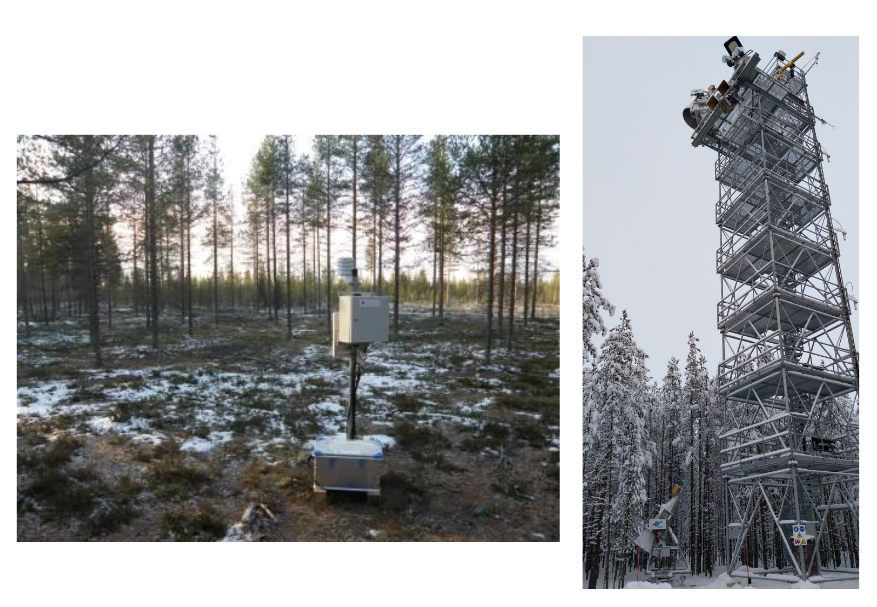
Automated soil station measuring ground permittivity (left) and tower-based radiometers (right) at Sodankylä. For 12 years, sensors placed 5 cm below the ground have measured ground permittivity, manual snow measurements have been used to calculate snow density, and 2 towers-based radiometers have previously been used to derive L-VOD model parameters for boreal forests © Finnish Meteorological Institute
The results show that SMOS data are in good agreement with the ground-based data in dry snow conditions: a Pearson correlation coefficient of 0.87 is obtained for the ground permittivity, and the dynamics predicted by the L-VOD model are clearly visible on the retrieved values. For snow density, in-situ and SMOS data seem to be in better agreement under stable mid-winter conditions (i.e. ground completely frozen and dry snow), but discrepancies remain to be resolved. Indeed, a major interest of snow density measurements is that they can potentially be used to improve existing satellite products that derive snow water equivalent. And currently, there is no remote sensing based information on snow density on a global scale…
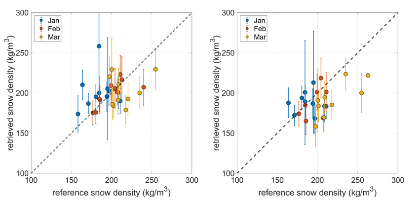
Reference snow density (SMOS) at (a) ascending and (b) descending orbits compared with reference snow density (in-situ) for 12 winters (2010 to 2022)
The recently published article : Retrieval of ground, snow, and forest parameters from space borne passive L band observations. A case study over Sodankylä, Finland
About modelling L-VOD from in-situ data : L-band Observations of Soil and Trees in Freezing/Thawing Conditions