Earth is covered with vegetation which stocks and releases carbon. Understanding the fluctuations of the so called Above Ground Biomass (total mass of vegetation above the surface) is thus of paramount importance when one wants to ascertain carbon sinks and sources. As we celebrate the successful launch of the Biomass satellite, let’s take a look at the different techniques already in use for its monitoring.
On the ground, several methods exist to estimate dry biomass by measuring parameters such as tree diameters or heights. However, applying these techniques on a global scale is a massive task, especially for regular monitoring ! This is where satellites come into play, as they cover the entire globe in just a few days. But very few existing datasets span more than 10 years. One approach combines in-situ measurements, satellite radar observations and LIDAR data from aerial campaigns with artificial intelligence. However, due to the associated uncertainties, the scientific community sought to refine these estimates with complementary observations.
This led to the idea of using microwave data (L-band, 21 cm) from SMOS satellite, which has been in orbit for more than 15 years. By using multiple viewing angles, it can quantify the impact of the water in vegetation on the received signal and, from there, estimate the mass of the vegetation above the surface.
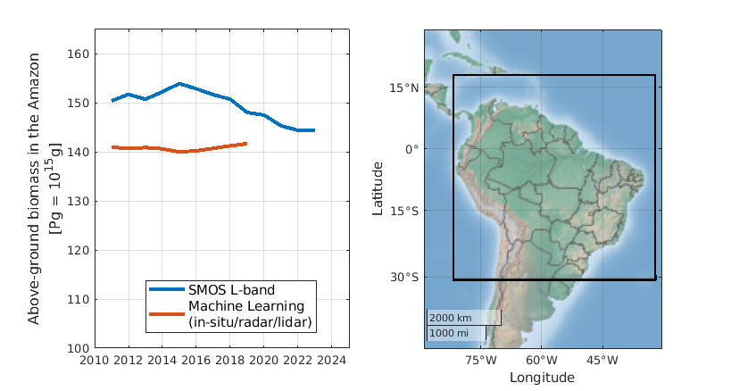
Blue: data from SMOS. Orange: data from in-situ/radar/LIDAR.
The two datasets have been compared across different regions, revealing new questions. For instance, why are there differing trends in the Amazon? “In light of the uncertainties, we understand the importance of using multiple estimation techniques” explains S. Boitard, author of the study. He also notes : “The first years of the Biomass satellite should shed additional light on these variations”.
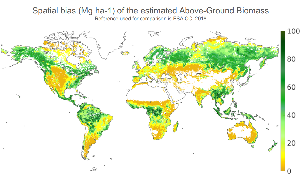
In the meantime, his paper provides an essential map of the associated spatial biases and highlights the knowledge gap that remains to be filled in some parts of the world. In spite of the large progresses made these last 15 years or so, research to improve above-ground biomass estimates is still open. So bear in mind that some statement made nowadays from these AGB estimates are not 100% fool proof!
And if you want to have some fun on this important topic, note that the AGB dataset from SMOS satellite are available on the CATDS website, for free !