New weekly and monthly fields of SMOS SSS in the Arctic Ocean are available at CATDS They have been generated by the LOCEAN CATDS/CEC Ocean Salinity Expertise Center, in collaboration with LOPS, AARI and ACRI-st colleagues.
These maps over the Arctic Ocean are based on SMOS-ESA nominal level 2 SSS adjusted with SST corrections and sea ice filtering derived from SMOS retrieved pseudo dielectric constant. The SST corrections are performed using REMSS Microwave+Infrared Sea Surface Temperature (SST) optimal interpolation product.
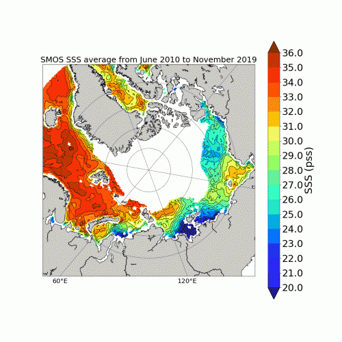
The level 3 (L3) SMOS ARCTIC SSS (weekly and monthly) covers a period from June 2010 to November 2019 above 60°North. SSS values are reprojected in an Equal-Scalable Earth Grid 2 (EASE, https://nsidc.org/data/ease) with a Northern Hemisphere Azimuthal projection and a resolution of 25km.
7-day moving averages of SMOS ESA L2 parameters are produced each day for L3 SSS weekly product. An average considering each day of the month is computed for L3 SSS monthly product. Weekly and monthly uncertainties are estimated through an error propagation of SMOS ESA v662 L2 uncertainty estimates.
Feedbacks from users about the quality of these new products are very welcome, as they are experimental.
These new products are fully described in Supply et al 2020 (https://doi.org/10.1016/j.rse.2020.112027).
Alexandre Supply et Jacqueline Boutin